


وصف لـ SwitzerlandMobility
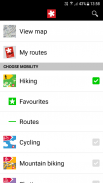
The free SwitzerlandMobility app is the perfect app for anybody who is out and about in Switzerland either in summer or winter:
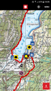
- maps of Switzerland from swisstopo up to a scale of 1:10,000 (the best)
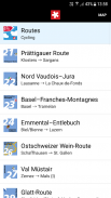
- 32,000 km signposted non-motorized routes (national, regional and local)
- complete network of signposted hiking trails (60,000 km)
- 500 routes for winter activities
- 25,000 public transportation stops linked to the timetable of the Swiss Federal Railways (planning a tour with public transportation was never easier)
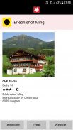
- information on 4,500 points of interest on the way, such as overnight accommodations, bicycle service stations, etc.
positioning system and compass function (you always know where you are)
With SwitzerlandMobility Plus you can additionally
- download and store swisstopo maps to be used in areas without network coverage (no more problems with dead zones)
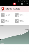
- download and store tours you designed, including elevation profile, hiking time, distance and altitude (separately and easily)
Please note:
- The app requires network coverage (useable without network coverage with SwitzerlandMobility Plus).
- No tours can be entered with the app.
Constant use of the GPS may considerably reduce the length of battery life.
Requires a screen resolution of min. 480x320 pixels (HVGA) and multitouch. Unfortunately, the Samsung GT-S6102 or GT-S5570, among others, does not fulfill this requirement.
تطبيق SwitzerlandMobility المجاني هو التطبيق المثالي لأي شخص موجود في سويسرا سواء في الصيف أو الشتاء:
- خرائط سويسرا من swisstopo حتى مقياس 1: 10،000 (الأفضل)
- الطرق غير الآلية التي تحمل علامات 32000 كم (وطنية ، إقليمية ، محلية)
- شبكة كاملة من مسارات رياضة المشي لمسافات طويلة (60000 كم)
- 500 مسار للأنشطة الشتوية
- 25000 محطة توقف للنقل العام مرتبطة بالجدول الزمني لخطوط السكك الحديدية الفيدرالية السويسرية (التخطيط لجولة مع وسائل النقل العام لم يكن أسهل من أي وقت مضى)
- معلومات عن 4500 نقطة مهمة على الطريق ، مثل أماكن الإقامة الليلية ومحطات خدمة الدراجات وما إلى ذلك.
نظام تحديد المواقع ووظيفة البوصلة (تعرف دائمًا مكانك)
مع SwitzerlandMobility Plus ، يمكنك إضافة ذلك
- قم بتنزيل وتخزين خرائط swisstopo لاستخدامها في المناطق التي لا تغطيها الشبكة (لم تعد هناك مشاكل مع المناطق الميتة)
- قم بتنزيل وتخزين جولات قمت بتصميمها ، بما في ذلك ملف تعريف الارتفاع ، ووقت المشي لمسافات طويلة ، والمسافة والارتفاع (بشكل منفصل وبسهولة)
يرجى الملاحظة:
- يتطلب التطبيق تغطية الشبكة (صالحة للاستخدام دون تغطية الشبكة مع SwitzerlandMobility Plus).
- لا يمكن إدخال جولات مع التطبيق.
الاستخدام المستمر لنظام تحديد المواقع العالمي (GPS) قد يقلل بشكل كبير من طول عمر البطارية.
يتطلب دقة شاشة دقيقة. 480 × 320 بكسل (HVGA) و اللمس المتعدد. لسوء الحظ ، لا تفي Samsung GT-S6102 أو GT-S5570 ، من بين أمور أخرى ، بهذا المطلب.
SwitzerlandMobility - إصدار 5.0.0
(02-03-2024)SwitzerlandMobility - معلومات APK
نُسخة APK: 5.0.0الحزمة: ch.schweizmobilتطبيقات من الفئة نفسها
قد يعجبك أيضًا...


